CycleStreets Gets Better
Posted by chdot on October 12, 2009
CycleStreets is the UK’s best cycle journey planner. It’s probably the only one that covers the whole of Great Britain and has a good understanding of where the cycle paths are. The underlying mapping is from Open Street Map which is the work of hundreds of volunteers (YOU could be one too).
CycleStreets originated in Cambridge where two members of the Cambridge Cycle Campaign created a cycle journey planner for the city using their computing skills and the dedicated mapping of a small group of residents. It seemed like a good idea to try to do the same for Edinburgh. A small amount of money was granted by the Scottish Government.
This helped to create edinburgh.cyclestreets.net and led to creation of a service that now has 1500placenames.cyclestreets.net.
One significant difference between Cambridge and Edinburgh is that Cambridge is mostly flat. (Edinburgh is actually a lot flatter than many non-cyclists realise – at least for many east/west journeys.) Initially, estimated journeys times were the same for both directions of a route. So The Mound to Canonmills ride was said to take the same time as the return trip!
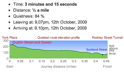
Now, after many months of hard work, CycleStreets can estimate the expected time of journeys in any direction – try it for yourself. Not only does the CycleStreets software understand gradients – and estimate fairly accurate journey times – it now produces gradient profiles for all suggested versions of the same journey – so you can easily see if the “quietest” route is also the hilliest.
 http://edinburgh.cyclestreets.net/journey/85010
 http://edinburgh.cyclestreets.net/journey/85011
Enjoy! (and feedback if the proposed routes seem ‘strange’)
You can also vote for CycleStreets – and help it get some more development money.
 cyclingedinburgh.info


Kim said
Whilst it is still in beta, it is has improved considerable since the last time I used it. It is now become a really useful tool, although a wee bit of local knowledge is still useful.
David said
I’m impressed by the format and the work put in. Though on a ride from High St to Cramond it ignored the Roseburn Path Route unless you went for quietest option.
Mind you it seemd happy to go round Haymarket Junction which I find most direct way for heading west.
When you live locally it’s easy to find bits that you may disagree with I suppose.
Also tram works are distorting things.